|
The socio-economic analysis for the evaluation of the economic and social benefit of disaster prevention and the development of the mentioned risk-based methodology will be based on empirical data derived by past case studies, such as the probabilistic flood warnings issued within the 2007 MAP D-PHASE experiment and a number of new case studies:
1) Zurich, Alpine catchments (floods and landslides)
2) Danube, Many countries Trans-boundary large river (large-scale inundations) 3) Barcellonette, France; Mountainous catchment, (landslides and debris flows) 4) Carlisle, United Kingdom; Urban area (urban floods) 5) Soča-Isonzo, Slovenia & Italy; Trans-boundary Alpine catchment (floods and landslides) 6) Somerset, United Kingdom; Coastal area, (storm surges) Zurich
The MAP D-PHASE (Demonstration of Probabilistic Hydrological and Atmospheric Simulation of flood Events in the Alpine region) project, the second Forecast Demonstration Project of the World Weather Research Programme, was run in summer and fall 2007 (Rotach et al. 2009). Its objective was to test and demonstrate the benefits in forecasting heavy precipitation and related flood events in real-time, by coupling atmospheric and hydrological models, especially in a probabilistic framework.

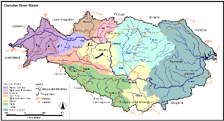
Danube
the Danube case study of the KULTURisk project will focus specifically on the socio-economic effects of large-scale inundations in transnational rivers by applying the risk-based methodologies developed in this project. It will furthermore pay special attention to the understanding of sophisticated probabilistic flood warning products, the information exchange and the communication between different regional and national authorities, and the increased preparedness to react in the case of a flooding when using a flood early warning system. The Danube case study will build on the currently pre-operational European Flood Alert System (EFAS) setup, which is an early flood warning system being developed at the Joint Research Centre of the European Commission. Its main goal is to provide European-wide, complimentary and harmonized information to national and regional systems as well as to the European Commission on possible river flooding to occur within the next 3 or more days.
 Barcellonette
The Barcelonette basin is drained by the Ubaye river and covers over 200km2. It is situated in the Southern Alps (France) in the dry intra-Alpine zone and is characterized by a mountain climate with a Mediterranean influence. The region has predominant outcrops of „Terres Noires‟ which are well known for their susceptibility to landslides and debris flows. The KULTURisk project will make use of the accumulated large amount of data on landslide and debris flow to demonstrate the socio-economic benefits of different risk prevention measures.
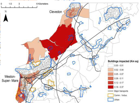
 Carlisle
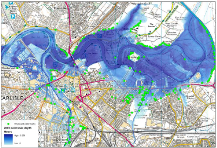
The British city of Carlisle will provide an urban flood risk mapping case study for the KULTURisk project. Carlisle experienced severe flooding on the morning of the 8th January 2005 after heavy rainfall over North West England the previous two days. The KULTURisk project will maintain contact with the end users such as the Environment Agency and local authorities that have been established by the FRMRC, whilst building on the lessons learnt from stakeholder workshops on flood risk perception and visualisation of probabilistic mapping products. Data collected shortly after the 2005 flood event provided one of the most comprehensive datasets for an urban flood currently available, which has supported hydraulic modelling projects. Hydraulic models developed by the University of Bristol and the FRMRC were also utilised for probabilistic inundation forecasting and visualisation and probabilistic flood hazard mapping. The state-of-the-art modelling and research conducted by the FRMRC will provide a platform on which the KULTURisk project will develop techniques to support a culture and understanding of flood risk mapping in Europe.
 Soča-Isonzo
The River Isonzo (Soča) is the largest river flowing into the Gulf of Trieste. It is a transboundary river which flows from Slovenia to the Adriatic Sea, in Italy. The catchment covers an area of 3400 km2, 66% of which is in Slovenia and 34% in Italy. In the upper part of the basin, which is one of the most rainy areas in Europe and is severely threatened also by earthquakes, frequent thunderstorms result in many flash floods and debris flows which caused several casualties in the past. The transboundary Soča-Isonzo Catchment will be used to test a very large variety of up-to-date prevention measures, including: coarse resolution scale ECMWF ensemble precipitation forecasting, small resolution ECMWF-surface real time observations, DIMOSHONG hydrological ensemble flood forecasting; standard flood hazard and risk mapping, advanced probabilistic flood hazard and risk mapping, structural measures for landslide and debris flow risk mitigation, monitoring and assessment of insurance policies implemented so far, communication to and feedback from end-users and stakeholders, socio-economic evaluation of costs and benefits resulting from the application of structural and non-structural measures, extension of the methodology to earthquake risk, which is very high in that area.
 Somerset
The Somerset levels coastal risk mapping case study extends along the 32 km stretch of coastline in the Severn Estuary, UK. This low lying area has a history of coastal flooding due to storm surges and includes a number of settlements. This case study will enable the KULTURisk project to deal not only with present day risk, but also with the nonstationarity due to climate, social and economic change.
 |

|
|
|
|
|
European project:
This project has received funding from the European Union’s Seventh Programme for research, technological development and demonstration under grant agreement No 265280
 |
|